


 x 90px (h)")
 x 90px (h)")


 x 90px (h)")


- AmaranthCX‘s has developed an interactive map of the coal mines and projects of South Africa’s Mpumalanga Highveld arranged by coal fields and overlaying the known coal bearing geology.
- The work in progress has been painstakingly gathered from dispersed sources of supposedly public information and coming soon to a web browser near you, for a modest subscription.
- All SA mines and many, many SA power generation projects.
This area is where most existing grid capacity for additional electrical generation is, and it is also where securing suitable renewable energy project sites is most difficult. A combination of urban and peri-urban areas, freehold and communal property, highly productive farm land – mainly maize, soya beans and sunflowers – extensive electrical infrastructure, active opencast and underground collieries and coal exploration projects, and a few hard won protected areas to preserve water sources.
The epicentre of the “Just Transition”.
And in terms of Section 53 of the Mineral and Petroleum Resources Development Act (MPRDA) any developer of a renewable energy project (or any non-agricultural project for that matter) needs to identify any mining or prospecting rights on, or within two kilometres of the perimeter of the proposed development and then apply to the Minister for Mineral Resources and Energy or his delegated local official (who must also identify and then consult with all affected rights holders) for permission to go ahead with the development.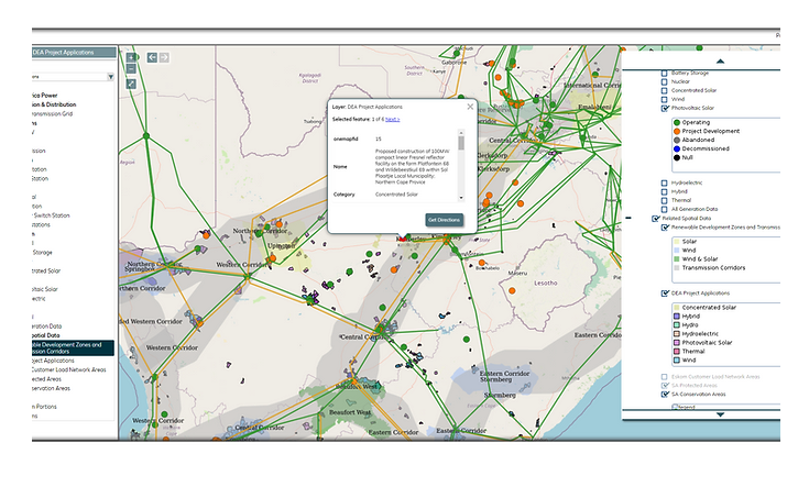 All things electrical across the 12 countries of the Southern African Power Pool. Image credit: AmaranthCX
This is to ostensibly prevent the current or future sterilisation of mineral resources, or more broadly prevent the achievement of any of the very wide, vague and often mutually contradictory objectives of the MPRDA – which, to be clear, does not have as one of its objectives reliable electricity supply.
Without a functional mining cadastre it is practically impossible for project developers to determine who has what rights where – and I have heard that the DMRE itself is taking upwards of 6-months just to identify which rights holders may be affected by a new project – a serious red tape road block, while the country sits in the dark for upwards of 10 hours a day.
A pro tip is to position your renewable project within the boundaries of a declared town, where Section 53 of the MPRDA doesn’t apply.
Author: Paul Miller
Paul is a director at Amaranthcx. Contact: paul.miller@amaranthcx.co.za
Disclaimer: The articles and videos expressed in this publication are those of the authors. They do not purport to reflect the opinions or views of Green Building Africa, our staff or our advertisers. The designations employed in this publication and the presentation of material therein do not imply the expression of any opinion whatsoever on the part Green Building Africa concerning the legal status of any country, area or territory or of its authorities.

