


 x 90px (h)")
 x 90px (h)")


 x 90px (h)")


- The Department of Mineral Resources and Energy (DMRE) in South Africa has approved a environmental impact assessment (EIA) go-head for London-based Searcher Geodata’s appointed environmental assessment practitioner, Environmental Impact Management Services (EIMS).
- Searcher proposes to commence with seismic surveys in Q1 2023 off the west coast of South Africa, subject to all approvals being in place.
Hydrocarbon deposits occur in reservoirs in sedimentary rock layers. Being lighter than water they accumulate in traps where the sedimentary layers are arched or tilted by folding or faulting of the geological layers. Marine seismic surveys are the primary tool for locating such deposits and are thus an indispensable component of offshore oil or gas exploration. 3D seismic surveys are conducted on a tight survey grid and provide an image of the seafloor geology along each survey track–line.
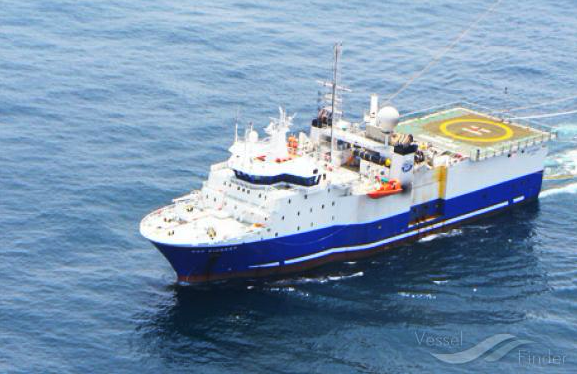
BGP PIoneer is part of the Searcher seismic survey project off South Africa’s West Coast. Image credit: Vessel Finder
Why is seismic surveys so controversial?
In 2D seismic surveying both the blast and sound detectors (numbering up to a hundred or more per charger) are moved along a straight line. In 3D seismic surveying the sound detectors (numbering up to a thousand or more) are spread out over an area and the blast is moved from location to location through the area. Seismic testing involves sending regular “blasts” under water in short sequence to create a map of the surface and sub-surface.
The noise generated can reach 250 decibels as the sound waves generated by the blast penetrate the seabed. In comparison, the loudest whale noises range between 140 and 190 decibels.
This sound is proven in multiple peer-reviewed research papers to disturb, scare and alter marine life such as separating whales and their calves. This affects the endangered African Penguin, two subspecies of Blue Whales, the Antarctic Blue Whale and the Pygmy Blue Whale, the protected Southern Right Whales, Bryde’s Whales, Loggerhead Sea Turtles, Orcas and multiple Shark species all found along the Western Cape coast.
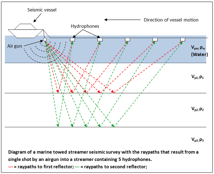
Diagram of a marine seismic survey. Image credit: Wikimedia Commons
The area of interest for the proposed 3D seismic survey is approximately 30 000 km2 in extent. The proposed project area is located between approximately 256 km offshore of St Helena Bay, extending north along the western coastline to approximately 220 km offshore of Hondeklip Bay. It is currently envisaged that the survey lines would have a NE-SW or SE-NW orientation. The 3D survey will take in the order of 127 days including downtime.
It is proposed that a single survey vessel equipped with seismic sources and streamers be used.
The proposed 3D survey would be supported by one escort vessel. The escort vessel will assist in monitoring for and alerting other vessels (e.g. fishing, transport, etc.) about the survey and the lack of manoeuvrability of the survey vessel. At a minimum, one Fisheries Liaison Officer (FLO) person speaking English and Afrikaans will be on board either the survey or the escort vessel to facilitate communication in the local language with the fishing (or other) vessels that are in the area. Additionally, there will be two Marine Mammal Observers on board the survey vessel to monitor for marine mammals and fauna visually and ensure that the survey is conducted in compliance with the specified guidelines as stated in the Environmental Management Programme.
Would you like to object?
Should you feel that you may be interested in, or affected by, this project, it is essential that you register as an Interested and Affected Party (I&AP) in which case you will be kept informed regarding the project and afforded an opportunity to participate in the process. Please note that only registered I&APs will be included in future correspondence regarding the project and associated updates. You may register and/or comment as an I&AP in any of the following ways:
- Complete the I&AP registration form and questionnaire and return it to EIMS via email, fax or post;
- Submit written comments, registrations, or requests to EIMS via email, fax or post; and/or
- Via telephone call.
It is important to note that the EIA process is guided by legally stipulated timeframes and as such, in order to ensure your continued and valuable involvement in the project, we request that your registration requests and any preliminary comments are submitted to EIMS (contact details provided below) by 12 August 2022.
Please note that further to the above, all registered I&APs will also be notified in due course of further participation opportunities, as well as the availability of the BA Report upon which comments will be solicited.
Environmental Impact Management Services (Pty) Ltd (EIMS) Contact Person: Qaphela Magaqa
EIMS Reference Number: 1518
Postal Address: P.O. Box 2083; Pinegowrie; 2123
Telephone: (011) 789 7170/ Fax: (086) 571 9047 E-mail: searcher@eims.co.za
Link to environmental notification here
Author: Bryan Groenendaal

